
Over half of the world’s eight billion population now lives in cities. These vibrant, diverse and ever-evolving urban centers are responsible for the vast proportion of global economic activity, yet they are also under threat. Rapid urbanization, climate change, aging infrastructures and frequent natural disasters already affect countless lives. Unless governments and city leaders take action and find ways to improve access to basic services, affordable housing, clean, efficient transportation and green spaces, even more people face an uncertain future.
To tackle these challenges head on and build truly climate-resilient cities and urban infrastructures, government authorities are fast learning that it’s not enough to simply amass data about the cities they run and the services they deliver. If they are to truly understand how to make citizens’ lives better, they must translate big data into actionable insights.
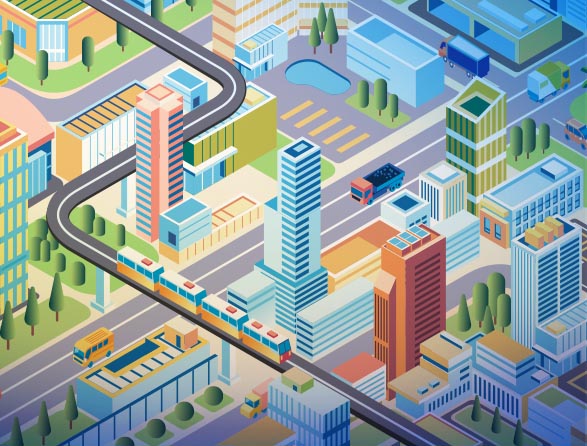
One way to do that is through virtual twins.
With virtual twins you can test out proposed improvements in the virtual world first and pinpoint vulnerable areas and build context-specific strategies that address both environmental and social concerns. Equipped with this information, governments can then work closely alongside local stakeholders and city planners to make sure any interventions are not only effective but resonate with the unique needs and priorities of the people they serve.
We caught up with Dassault Systèmes’ Cities and Public Services business consultant Ismail Hamoumi about how public sector organizations can make better use of their data and take advantage of the latest virtual twin and simulation capabilities to anticipate future risks and develop effective solutions for the cities of today and tomorrow:
Urban planning data is now one of the most important assets for public sector organizations and businesses. How can it be harnessed for the benefit of cities and public services?
The digital revolution and the proliferation of the internet of things (IoT) has created a context in which data is omnipresent but usually lacking in quality. To get the most value from data, public sector players must determine how they intend to collect, aggregate, structure and use it. With this information, they can do things like:
- Get a holistic understanding of the city complexity by integrating multiple systems such as transportation, education, housing, parks, etc.
- Better manage urban projects
- Facilitate collaboration by breaking siloes
- Improve relations with citizens
- Optimize public consultations surrounding public policies
Backed by virtual twin capabilities, whereby local authorities create a virtual representation of their territory, they can take this a step further and virtually test their public policies, work on territorial planning or simulate certain crisis situations, such as flooding or heat waves.
How can virtual twin experiences be used to connect the virtual and physical worlds and provide greater visibility of what’s happening in cities and public services?
City leaders can recreate the exact replica of their territory in a virtual twin to facilitate choices, analyse the impacts of future projects or anticipate a crisis. In the context of urban planning, virtual twins have powerful capabilities for envisioning and implementing public policies and urban plans before they manifest in the real world. This capability allows for a meticulous analysis of potential outcomes and empowers public administrators to foresee the implications of various policy choices and urban developments.
Dassault Systèmes’ products and solutions have supported cities and public players in various fields. For urban planning, our teams are proud to have supported the city of Rennes Métropole by enabling them to digitize their heritage and help them plan and build new districts. Our technology has helped them facilitate remote data sharing in order to simulate, plan and manage the city in a collaborative way, to develop effective public policies.
Additionally, Dassault Systèmes was able to model the Paris mayor’s decision to allocate a lane of the Paris Ring Road to car sharing to help with traffic and decrease CO2 emissions. Through simulation, we could scientifically analyze the impact on the traffic itself – with and without incentives for car sharing – and on air and noise pollution for residents of the neighborhood.
In what ways can data analytics be used to build strategies that address both environmental concerns and social equity?
Tackling the environmental and climate crisis requires a detailed diagnosis of the current state of our activities. Yet many regions do not have a clear picture of their carbon footprint. Collecting and cross-referencing data on mobility flows, logistics, pollutants from industrial activities and energy consumption will help to highlight correlations or causalities between different phenomena in an urban space and determine how polluting activities impact populations. Elected representatives can then develop more scientific and robust approaches to steering their public policies and combating the causes of climate change.
Environmental concerns are now very related to health and social equity. Therefore, local authorities have to ensure quality of life is similar and for all residents wherever the area they live in.
How might virtual twin and simulation capabilities support sustainability initiatives?
The outcomes of sustainability initiatives can be very complex to track. However, with virtual twin and simulation capabilities, one can analyze the real impact of different factors – such as traffic – on a given area. By using advanced simulation to model and quantify the impact of traffic, congestion, air, and noise pollution, city officials can use this information and make smarter decisions – like deciding that a given pedestrian area should not allow motorcycles, as it would therefore worsen congestion and air quality for its citizens.
Public sector organizations need to be able to understand the unique needs and priorities of the people they serve. What data driven city planning solutions are available to help them do this effectively?
Citizen participation is key to ensuring the adoption of new public policies. This can be achieved through workshops, interviews and surveys as well as monitoring usage rates of public transport, sports facilities, cultural services and libraries.
Some cities use virtual twins to demonstrate new projects to their residents. Métropole de Rennes in France has a “project house” where citizens can meet city representatives to view future projects and ask questions. It is also key to listen to citizens’ opinions which is possible with data analytics tools using sophisticated natural language processing and semantic analysis capabilities to the table so that municipalities can glean insights from vast quantities of unstructured text data, such as social media posts, public feedback, and other digital communications. This allows them to capture regular feedback from the public on a variety of issues and events related to the city and tailor communication strategies to better meet the community’s needs.
In what areas are virtual twins having the greatest impact?
Whether it is managing natural resources or planning new urban developments, virtual twin capabilities help local authorities make more informed decisions. Some virtual twin technology even offer advanced simulation tools to test and analyze structural, fluid and electromagnetic properties within urban environments – ideal for understanding how proposed public policies and urban infrastructures will perform under a variety of conditions, including extreme weather events and high-stress situations.
Other potential uses of the virtual twin include:
- Precise planning and optimized renovation: The virtual twin of the territory can integrate a variety of BIM models for simplifying and better organizing building management and multi-site renovation processes. It redefines project management, smoothing out the entire workflow and making best use of available resources.
- Promoting sustainability and circularity initiatives: The virtual twin helps to identify circularity potential and understand local climate and environmental issues, becoming a real lever for informing public decision-makers about current and future risks.
What makes Dassault Systèmes an ideal technology partner for public sector organizations and local authorities?
Dassault Systèmes’ approach is characterized by close collaboration with municipalities, understanding their unique challenges, and tailoring our solutions to these needs. Our virtual twin experiences for infrastructure and cities are not just tools but partners in driving economic development and enhancing the quality of urban life. By integrating our solutions, cities can optimize resource allocation, streamline operations, identify environmental risks (air pollution, flooding and heatwaves), and ultimately enhance the efficiency of public services.
Final thoughts
As people continue moving into cities and climate change continues to pose a threat, using data for city planning for smarter decision-making will become critical. Whether it’s analyzing the impact of traffic on air pollution, planning for crisis situations like flooding and heat waves, or gaining citizen feedback on new public policies, virtual twins can help city planners with their most complicated urban projects.
Related resources

Rebecca Lambert est journaliste et copywriter freelance basée en Grande-Bretagne.